
Main menu

  • Home
  • Current Issue
  • Archive
  • About Us
    • About NAVIGATION
    • Editorial Board
    • Peer Review Statement
    • Open Access
  • More
    • Email Alerts
    • Info for Authors
    • Info for Subscribers
  • Other Publications
    • ion

User menu

  • My alerts

Search

  • Advanced search
NAVIGATION: Journal of the Institute of Navigation
  • Other Publications
    • ion
  • My alerts
NAVIGATION: Journal of the Institute of Navigation

Advanced Search

  • Home
  • Current Issue
  • Archive
  • About Us
    • About NAVIGATION
    • Editorial Board
    • Peer Review Statement
    • Open Access
  • More
    • Email Alerts
    • Info for Authors
    • Info for Subscribers
  • Follow ion on Twitter
  • Visit ion on Facebook
  • Follow ion on Instagram
  • Visit ion on YouTube
Research ArticleOriginal Article
Open Access

AGPC-SLAM: Absolute Ground Plane Constrained 3D Lidar SLAM

Weisong Wen and Li-Ta Hsu
NAVIGATION: Journal of the Institute of Navigation September 2022, 69 (3) navi.527; DOI: https://doi.org/10.33012/navi.527
Weisong Wen
Hong Kong Polytechnic University
  • Find this author on Google Scholar
  • Find this author on PubMed
  • Search for this author on this site
Li-Ta Hsu
Hong Kong Polytechnic University
  • Find this author on Google Scholar
  • Find this author on PubMed
  • Search for this author on this site
  • For correspondence: [email protected]
  • Article
  • Figures & Data
  • Supplemental
  • References
  • Info & Metrics
  • PDF
Loading

Article Figures & Data

Figures

  • Tables
  • Additional Files
  • FIGURE 1
    • Download figure
    • Open in new tab
    • Download powerpoint
    FIGURE 1

    Overview of the applied coordinate systems
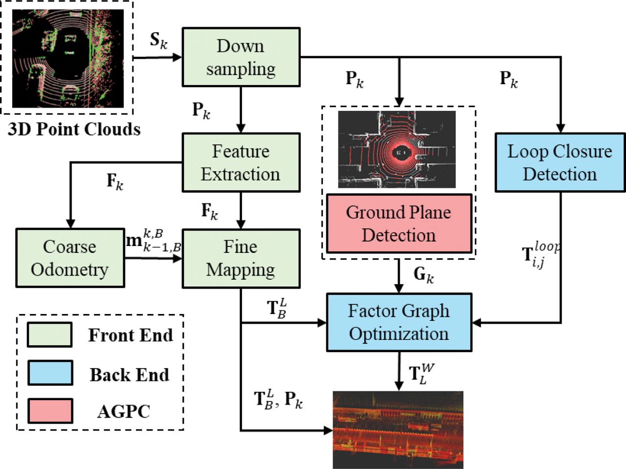
  • FIGURE 2
    • Download figure
    • Open in new tab
    • Download powerpoint
    FIGURE 2

    Overview of the proposed AGPC-SLAM; the input is the 3D point cloud from 3D lidar. The outputs include the points map and pose estimation of vehicular trajectory.
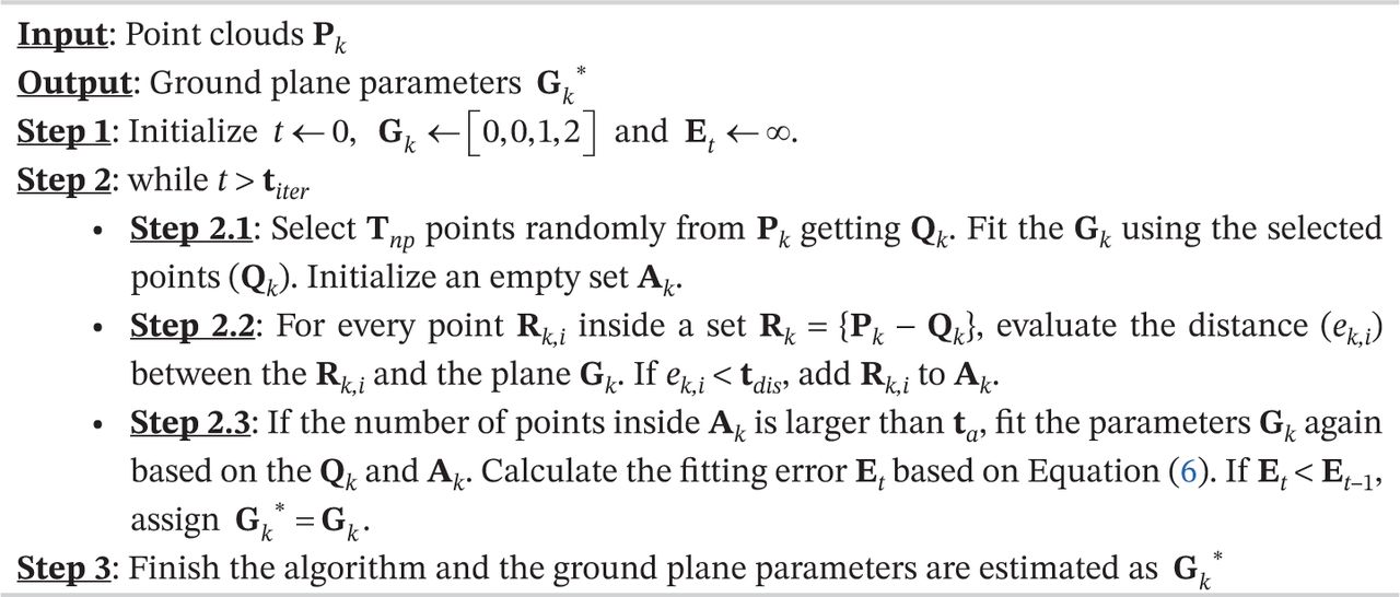
  • ALGORITHM 1
    • Download figure
    • Open in new tab
    • Download powerpoint
    ALGORITHM 1

    Ground Plane Detection Using RANSAC
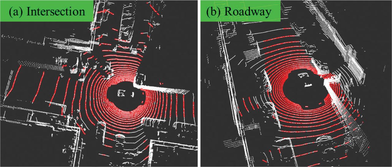
  • FIGURE 3
    • Download figure
    • Open in new tab
    • Download powerpoint
    FIGURE 3

    Illustration of ground detection using Algorithm 1 (the white points represent the raw point cloud from 3D lidar and the red points denote the detected ground point cloud).
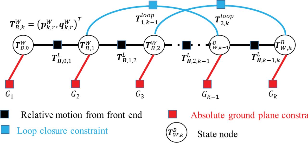
  • FIGURE 4
    • Download figure
    • Open in new tab
    • Download powerpoint
    FIGURE 4

    Graph structure of the proposed AGPC-SLAM

  • FIGURE 5
    • Download figure
    • Open in new tab
    • Download powerpoint
    FIGURE 5

    (a) Data collection vehicle with all the sensors installed in a compact sensor kit; (b) tested scenarios; and (c) trajectory with a driving distance of 4.2 km
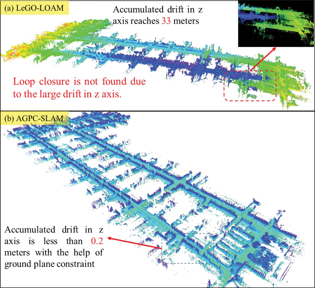
  • FIGURE 6
    • Download figure
    • Open in new tab
    • Download powerpoint
    FIGURE 6

    Illustration of the map generated by the two methods; the color of the map is annotated by the value of the z-axis (height) of each point.
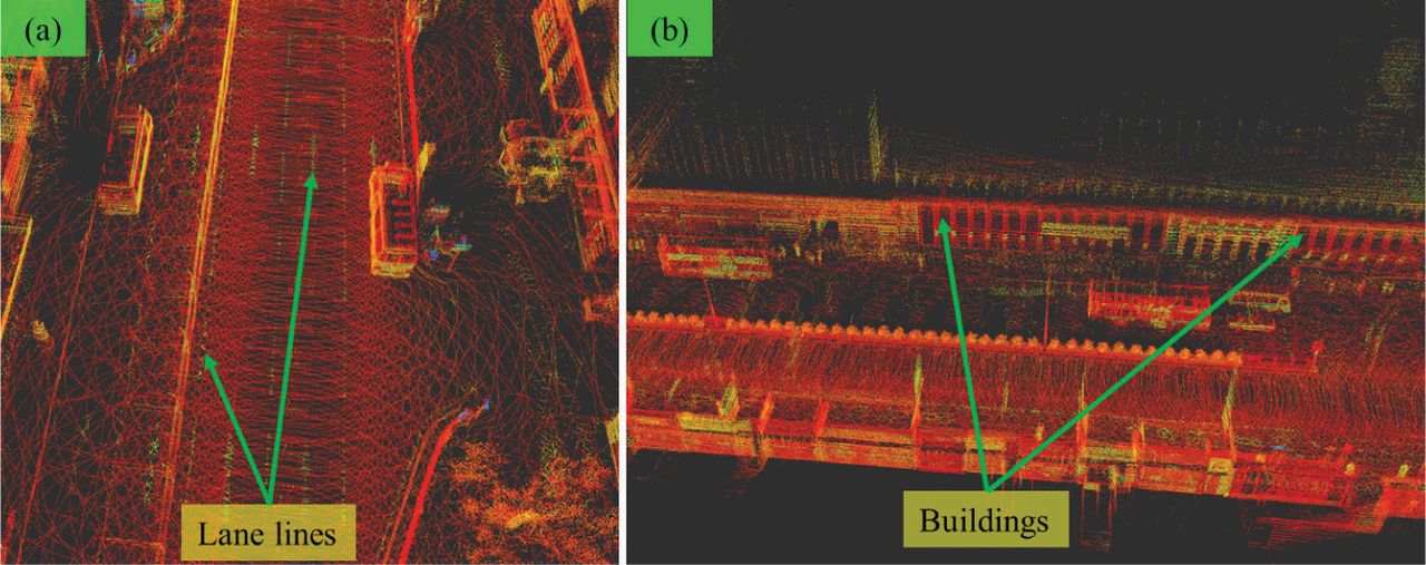
  • FIGURE 7
    • Download figure
    • Open in new tab
    • Download powerpoint
    FIGURE 7

    Details of the generated map with reflectivity using the proposed AGPC-SLAM in Location 1

  • FIGURE 8
    • Download figure
    • Open in new tab
    • Download powerpoint
    FIGURE 8

    (a) Environmental condition at the start point (blue shaded circle); (b) the scene with partial ramp road (red shaded area)

  • FIGURE 9
    • Download figure
    • Open in new tab
    • Download powerpoint
    FIGURE 9

    Trajectories of the LeGO-LOAM (red curve), AGPC-SLAM (blue curve), and ground truth trajectory (black curve)
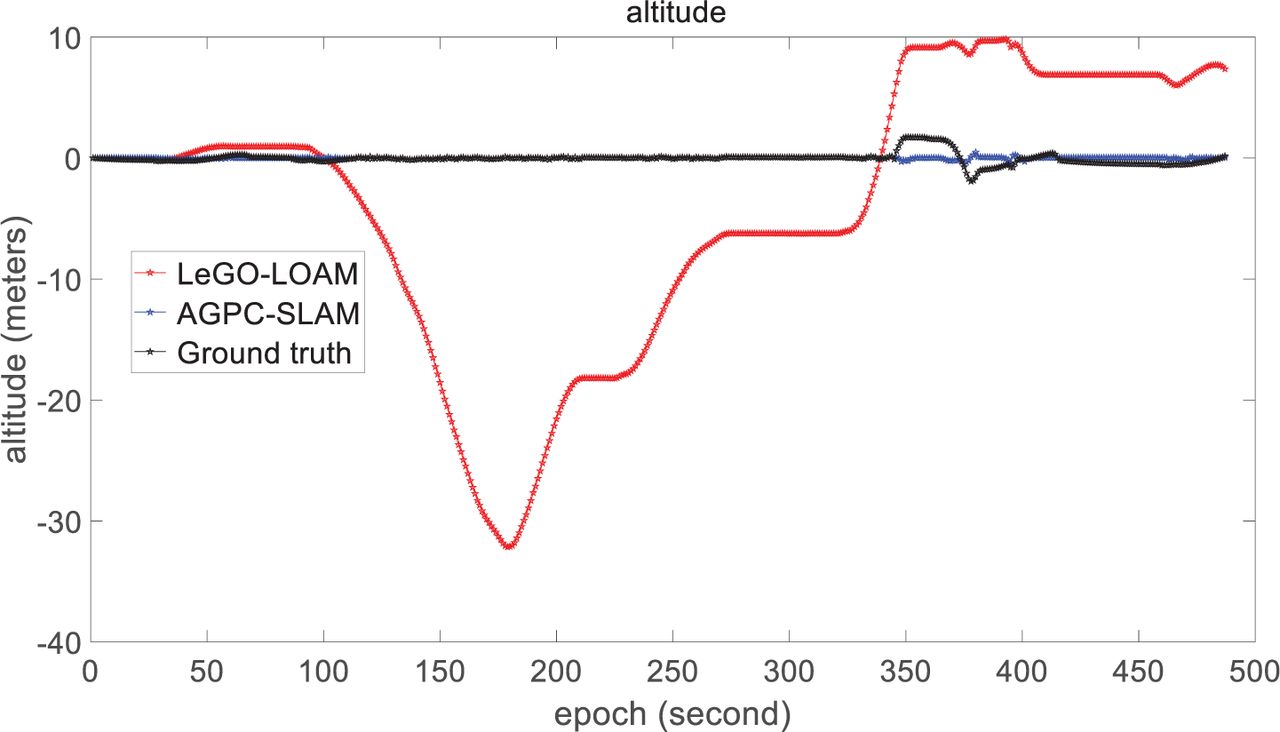
  • FIGURE 10
    • Download figure
    • Open in new tab
    • Download powerpoint
    FIGURE 10

    Altitude of the LeGO-LOAM (red curve), AGPC-SLAM (blue curve), and ground truth trajectory (black curve) during the testing area with the ramp road
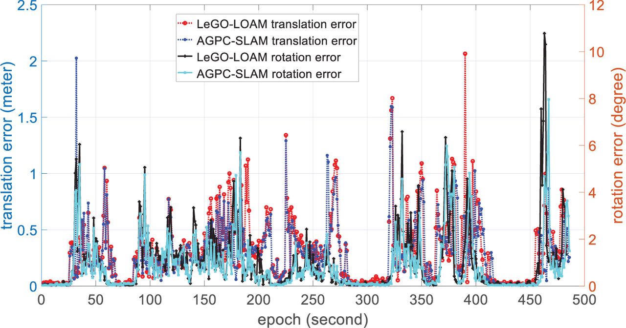
  • FIGURE 11
    • Download figure
    • Open in new tab
    • Download powerpoint
    FIGURE 11

    Relative translation and rotation errors for LeGO-LOAM and the proposed AGPC-SLAM, respectively
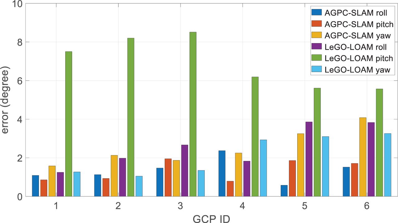
  • FIGURE 12
    • Download figure
    • Open in new tab
    • Download powerpoint
    FIGURE 12

    Errors of the roll, pitch, and yaw angles for LeGO-LOAM and the proposed AGPC-SLAM (the x-axis denotes the ID of the GCPs from 1 to 6 and the y-axis denotes the errors)
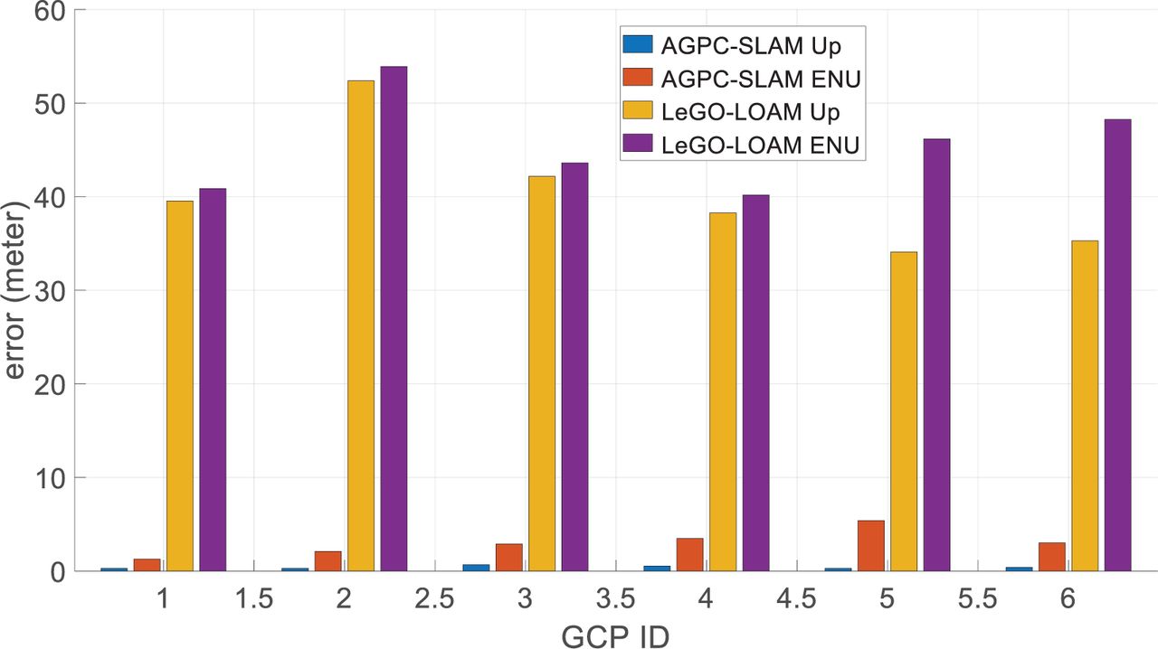
  • FIGURE 13
    • Download figure
    • Open in new tab
    • Download powerpoint
    FIGURE 13

    Errors of the up (altitude) and ENU for LeGO-LOAM and the proposed AGPC-SLAM, respectively (the x-axis denotes the ID of the GCPs from 1 to 6 and the y-axis denotes the errors)

Tables

  • Figures
  • Additional Files
    • View popup
    TABLE 1

    Parameters Used During Experimental Validation

    Para.tnptdistatitertD
    Values8000.25500100020.0
    Para.tFEmbedded ImageEmbedded ImageEmbedded Imagetc
    Values0.8010 I6×610 I6×64 I3×30.1
    • View popup
    TABLE 2

    Performance of Rotation Estimation at Location 1

    MethodRollPitchYawTotal%
    LeGO-LOAM (Shan & Englot, 2018)2.57°6.93°2.16°7.70°0.18%
    AGPC-SLAM (proposed)1.36°1.35°2.61°3.24°0.07%
    AGPC-SLAM (with loop closure)1.29°1.21°1.53°2.33°0.056%
    • Note: %: [Total]/[total driving distance]

    • View popup
    TABLE 3

    Performance of the Translation Estimation at Location 1

    MethodEastNorthUpENUAE%
    LeGO-LOAM (Shan & Englot, 2018)3.89m11.58m43.83m45.49m34.80m1.08%
    AGPC-SLAM1.39m2.65m0.41m3.02m1.89m0.04%
    AGPC-SLAM (loop closure)1.32m2.36m0.40m2.73m0.52m0.065%
    • Note: AE: accumulated absolute error. %: [ENU]/[total driving distance]

    • View popup
    TABLE 4

    Performance of the Translation and Rotation Estimation in Location 2

    MethodMEANRMSEAltitudeAE%
    LeGO-LOAM (Shan & Englot, 2018) (Translation)0.33 m0.46 m7.36 m8.92 m0.42%
    AGPC-SLAM (Translation)0.27 m0.38 m0.21 m5.26 m0.26%
    LeGO-LOAM (Shan & Englot, 2018; Rotation)0.69°1.22°Embedded Image3.72°0.19%
    AGPC-SLAM (Rotation)0.58°1.07°Embedded Image1.87°0.09%
    • View popup
    TABLE 5

    Performance of Translation and Rotation Estimation with Loop Closure

    MethodTrans. RMSERot. RMSEAltitude
    LeGO-LOAM (Shan & Englot, 2018; Loop closure)Loop Not DetectedLoop Not DetectedLoop Not Detected
    AGPC-SLAM (Loop closure)0.43 m0.64°0.13 m

Additional Files

  • Figures
  • Tables
  • Video Abstract

PreviousNext
Back to top

In this issue

NAVIGATION: Journal of the Institute of Navigation: 69 (3)
NAVIGATION: Journal of the Institute of Navigation
Vol. 69, Issue 3
Fall 2022
  • Table of Contents
  • Index by author
Print
Download PDF
Article Alerts
Sign In to Email Alerts with your Email Address
Email Article

Thank you for your interest in spreading the word on NAVIGATION: Journal of the Institute of Navigation.

NOTE: We only request your email address so that the person you are recommending the page to knows that you wanted them to see it, and that it is not junk mail. We do not capture any email address.

Enter multiple addresses on separate lines or separate them with commas.
AGPC-SLAM: Absolute Ground Plane Constrained 3D Lidar SLAM
(Your Name) has sent you a message from NAVIGATION: Journal of the Institute of Navigation
(Your Name) thought you would like to see the NAVIGATION: Journal of the Institute of Navigation web site.
Citation Tools
AGPC-SLAM: Absolute Ground Plane Constrained 3D Lidar SLAM
Weisong Wen, Li-Ta Hsu
NAVIGATION: Journal of the Institute of Navigation Sep 2022, 69 (3) navi.527; DOI: 10.33012/navi.527

Citation Manager Formats

  • BibTeX
  • Bookends
  • EasyBib
  • EndNote (tagged)
  • EndNote 8 (xml)
  • Medlars
  • Mendeley
  • Papers
  • RefWorks Tagged
  • Ref Manager
  • RIS
  • Zotero
Share
AGPC-SLAM: Absolute Ground Plane Constrained 3D Lidar SLAM
Weisong Wen, Li-Ta Hsu
NAVIGATION: Journal of the Institute of Navigation Sep 2022, 69 (3) navi.527; DOI: 10.33012/navi.527
Reddit logo Twitter logo Facebook logo Mendeley logo
  • Tweet Widget
  • Facebook Like
  • Google Plus One
Bookmark this article

Jump to section

  • Article
    • Abstract
    • 1 INTRODUCTION
    • 2 RELATED WORK
    • 3 OVERVIEW OF THE PROPOSED METHOD
    • 4 METHODOLOGY
    • 5 EXPERIMENT RESULTS AND DISCUSSIONS
    • 6 CONCLUSION AND FUTURE WORK
    • HOW TO CITE THIS ARTICLE
    • APPENDIX: PERFORMANCE OF AGPC-SLAM AT 6 GCPS
    • REFERENCES
  • Figures & Data
  • Supplemental
  • References
  • Info & Metrics
  • PDF

Related Articles

  • Google Scholar

Cited By...

  • No citing articles found.
  • Google Scholar

More in this TOC Section

  • GPS Spoofing Mitigation and Timing Risk Analysis in Networked Phasor Measurement Units via Stochastic Reachability
  • A Consistent Regional Vertical Ionospheric Model and Application in PPP-RTK Under Sparse Networks
  • Real-Time Ionosphere Prediction Based on IGS Rapid Products Using Long Short-Term Memory Deep Learning
Show more Original Article

Similar Articles

Keywords

  • dynamic object
  • ground plane constraint
  • lidar SLAM
  • urban canyons

Unless otherwise noted, NAVIGATION content is licensed under a Creative Commons CC BY 4.0 License.

© 2023 The Institute of Navigation, Inc.

Powered by HighWire